
This feature first appeared in March 2024 on Londonist: Time Machine, our much-praised history newsletter. To be the first to read new history features like this, sign up for free here.

The highest mound in Rotherhithe didn’t exist 40 years ago. Within many of our lifetimes, this was a deep, water-filled trench.
I’m stood before Stave Hill, crowning glory of a local nature reserve about a mile east of Tower Bridge. It thrusts up almost at the exact centre of the Rotherhithe Peninsula like a suburban Silbury.

I call it — perhaps provocatively — London’s least historic hill because, well, it has no history. It was built in 1984, the year of Ghostbusters, The Terminator and Police Academy. This modern mound was pulled into coherence from the detritus of old docklands; a raspberry rubble ice cream scoop plonked within a manufactured nature reserve.
The hill itself might lack history, but it certainly has an origin story. As late as the 1970s, Rotherhithe looked a bit like this:
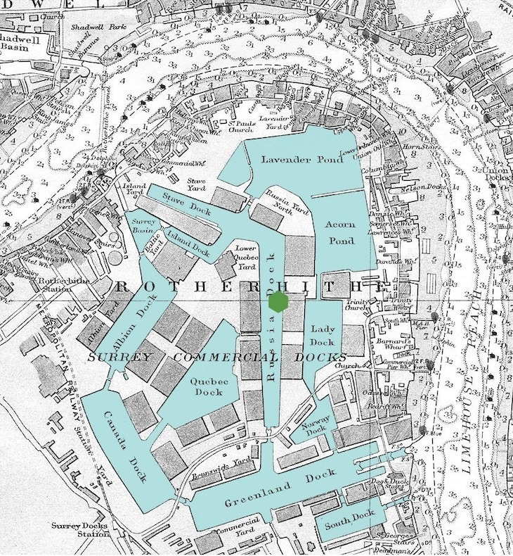
Almost the entire peninsula was given over to basins and warehousing, an industrial landscape known as the Surrey Commercial Docks. Their main purpose was to handle timber imports. This is where the name Stave Hill comes from. Staves are rounded cuts of wood, commonly used in barrels. We can see a Stave Dock and Stave Yard in the map above. The future hill would perpetuate their name.
Rotherhithe was the ideal location to build such a dense complex of shipping berths. The land was sparsely populated, low-lying and marshy — unsuited to cultivation, but easily shaped into docks and channels. The first excavations came in the 17th century and the area gradually developed into the intricate complex shown in the map. Over the following centuries, tens of thousands of ships visited these inland moorings. Hundreds of thousands of dockers worked here, over many generations.
Surrey Commercial Docks were heavily bombed in the war. They may have eventually recovered, but the advent of containerised shipping from the 1960s sounded the death knell. By the end of the decade, the docks had closed and the process of infilling began. Today, Rotherhithe looks very different. Only Greenland Dock, South Dock and part of Canada Dock remain. Almost everything else is housing.

The land where Stave Hill now stands was once the Russia Dock, so named because it handled cargo from that region. Today, the mound is utterly landlocked, save for a chain of ponds a few minutes’ walk away.
Back in the present, I climb to the top. It’s not exactly fatiguing. The tumulus rises just 9.1 metres above its surroundings — there are taller sandcastles in the world — but it’s still enough to make this the loftiest land point in the area. The views are rather special, if you like random clusters of blocky skyscrapers.

The summit offers something more than a view — a rather lovely 3D map of the area, sculpted by Michael Rizzello. He’s the chap who created the statue of Darcey Bussell on Oxford Street. (What do you mean you didn’t know there was a statue of Darcey Bussell on Oxford Street?)

I’ve been up here after rain. The water pools in the hollows, recreating the long-lost docks in miniature.

Isn’t that brilliant?
I like to imagine future archaeologists excavating the hill, hoping to find the burial site of a forgotten Chieftain of Rotherhithe, or the lost foundations of the fabled Shard, which legend says once towered over the southern shores of the Thames. But all they’ll discover is rubble and earth. The mound was formed from the spoil of the Albion Channel — a narrow waterway dug through the western part of the peninsula in the early 1980s, as a water feature for the new housing estates.

It’s worth taking some time to explore the surrounding 35 acres of woodland and nature reserve, too. I had the place almost to myself on an early morning spring visit. I clocked seven squirrels, an armada of coots, the tamest of dunnocks, an awkward-looking heron (aren’t they always) and a general passerine cacophony — none of which would have been here a couple of generations ago.
Stave Hill is not the only modern mound in the capital, of course. The so-called Beckton Alps in east London were formed from the dumping of toxic ash, and briefly served as a ski slope. At a similar latitude west of centre, Northala Fields arcs around a series of mounds built from the rubble of the old Wembley Stadium.
Those are both on the edge of the capital. The artificial butte of Stave Hill is the one to come to if you want views of London proper. And there is no better spot in this city to ponder the complicated tradeoffs of regeneration. We’ve lost an historic landscape where labourers grafted for centuries. But we’ve gained thousands of family homes, the songs of dunnock and chiffchaff, and a peculiar hill that’s no older than Footloose, yet stands as a potent symbol of the ever-changing city. That’s quite a history.
Visiting Stave Hill: Catch the Jubilee line or Windrush line to Canada Water. It’s then a 10-15 minute walk (you’ll need a map), which can take in the Albion Channel and part of the nature reserve. While you’re in the area, the library next to the tube station is of architectural interest, has toilets, and a decent cafe. And check out the new, red bridge.


