
This feature first appeared in September 2024 on Londonist: Time Machine, our much-praised history newsletter. To be the first to read new history features like this, sign up for free here.
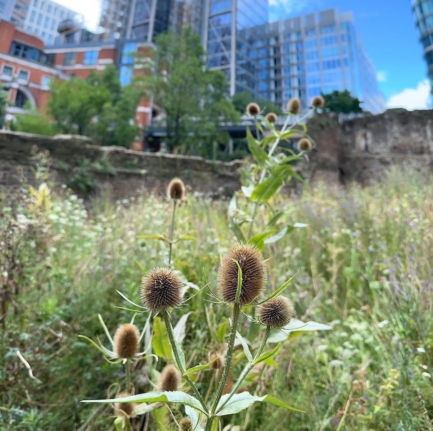
A wagtail bobs across medieval stone. Hover flies tango with teasel. A pea-green lake wobbles in the wind. Brimstone butterflies, fox turds, a transmural meadow. None of these pop into the mind when somebody says that loaded word: “Barbican”.
The 40 acre estate on the norther edge of the City is more often noted for its megatons of concrete, its brutalist towers and its labyrinthine highwalks. It arose in the 1960s from one of the most heavily bombed parts of London. To see how scarred this place was, just watch the curiously unplugged Unit 4+2 in this 1965 promo video for Concrete and Clay. And remember, this is more than 20 years after the Blitz.
Virtually nothing remains of the area from before the war. The Barbican complex was a fresh start, a tabula rasa. It wiped away almost everything that the Luftwaffe had not already shattered. But not quite everything. Here and there, historical artefacts remain. And let's remember that its name, Barbican, is itself an historical call-back to the Roman and medieval fortifications that still characterise the area. Let’s go in search of the ancient Barbican.
St Giles Cripplegate
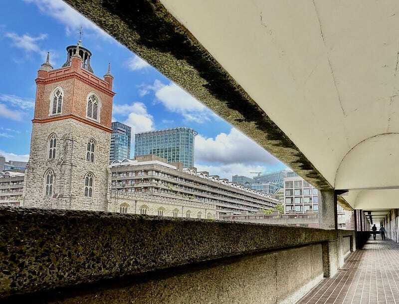
St Giles-without-Cripplegate is the most obvious pre-war survivor. Its stone is of a similar hue to the surrounding concrete blocks. What a tease on the eye; chromatic concord with architectural discord. And, oh dear, I seem to have slipped into pretentious twaddlespeak already.
The ‘without’ part of the church’s name originally meant ‘outside’ — outside the Cripplegate, which was one of the ancient portals into the city. The gate is long vanished, and the term ‘Cripplegate’ rarely used. St Giles is now without Cripplegate in more sense than one.
The church we see today is something of a mish-mash. It was, of course, badly damaged in the Blitz and had to be rebuilt. However, large chunks of the stonework are Tudor or even medieval. Oliver Cromwell was married here. John Bunyan worshipped here. John Milton is buried here. And, so far as I know, it is the only London church with a stained-glass window that features a skyscraper:
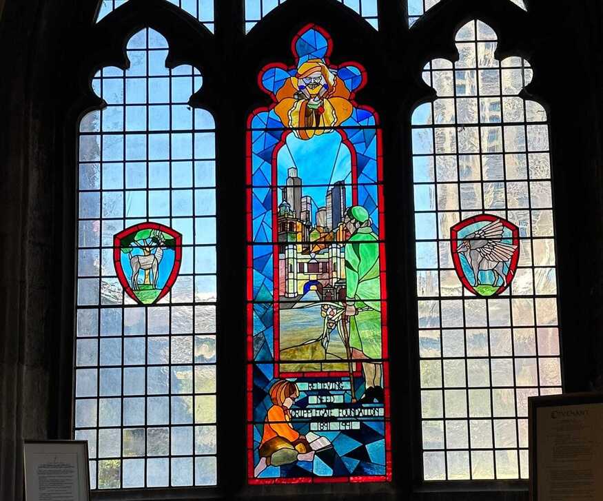
I do like this window. Look closely and you’ll see an anachronism. The mid-ground shows the old Cripplegate, demolished in the 18th century. But behind it rises the NatWest Tower (now Tower 42) and other 20th century skyscrapers. London is a city where different eras often surface together, and this is a delicious and deliberate example.
Old maps show St Giles with a larger than average churchyard. That grassy, open space has long since been swept away, but some of the grave markers remain. Look towards the church from the highwalk known as Wallside, and you’ll spot these gravestones set into the lakeside wall. I can’t guarantee the fitness guru will be there on your visit.
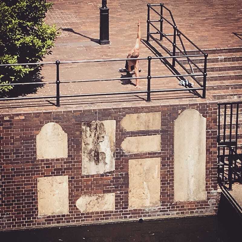
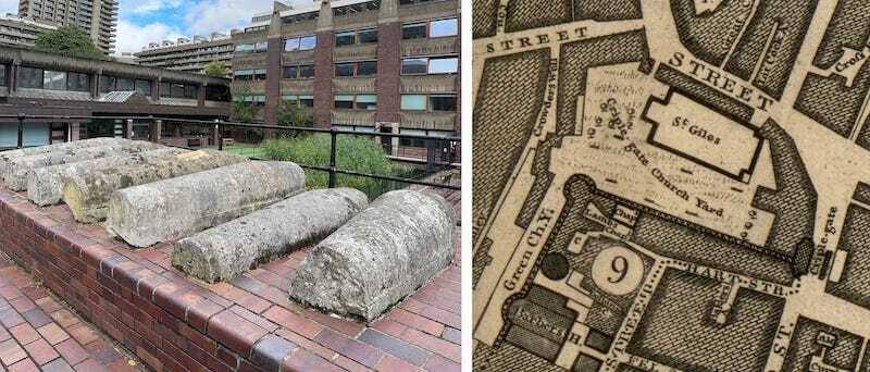
That’s not all. Towards the western end of the church plaza, a curious septet of sarcophagus-shaped grave markers cluster together. Each one marked the final resting place of a real Londoner, whose names and lives are now lost to us. Each one was mourned. But all are now forgotten, their tombs cracked and curated into an obscure corner of a housing development they could never have imagined.
By chance, the 1746 John Rocque map depicts seven linear features in the churchyard. It couldn’t be… could it?
Roman and medieval wall
If you look again at the map above, there’s a strip of land leading south-southwest from the churchyard, here labelled Green Ch.Y. We already met this green finger. Today, it’s the teasel-nurturing meadow shown in the first photograph to this article. The land sits just outside the old Roman wall, and would have once been part of the defensive ditch for the Cripplegate Fort. I suspect it has never been developed. Have archaeologists ever investigated?
The map above shows significant stretches of wall, along with the remains of two rounded towers. All of this still exists, and you might have seen it had you peered out of the viewing window in the old Museum of London’s Roman gallery.
If you’ve never explored this area then I commend it to you with every puff of breath I can muster. For starters, it’s an adventure to get to. You have to furtively make your way down a car ramp off London Wall, then turn right onto an unpaved, unsigned track amid the ruins.
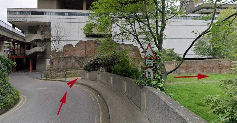
Honestly, if you get nothing else from this newsletter, ever, then note this on your to-do list. You need to explore this special place soon, because the upcoming redevelopment of Bastion House and the old Museum of London will likely put it off-limits for a few years, and will radically change its secluded, secretive, ‘should I really be here?’ aspect. And London will be robbed of another Narnia moment.
St Alphage
The other impressive stretch of Roman wall in these parts is a little to the east along the side-street known as St Alphage Garden. Here, the wall is unique because it retains brick crenellations thought to date from the Wars of the Roses.
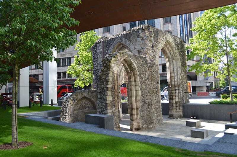
The real star here, though, is the remains of the tower of St Alphage — a significant medieval church built right up against the wall. The Barbican’s highwalks used to wrap clumsily around this ruin, part concealing it in a cold, orthogonal embrace. Recent redevelopment has greatly improved its setting with landscaped gardens and a gently curving pedway snaking over the site. Because, just sometimes, massive redevelopment can improve our heritage assets.
Other historical oddities
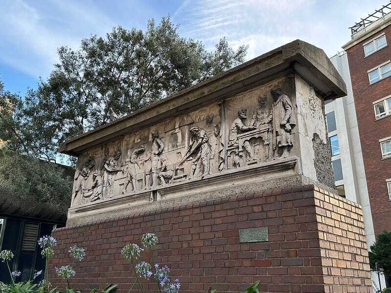
One further pre-war fragment can be found where Aldersgate Street becomes Goswell Road. This frieze once decorated a gold-refiner’s premises at 53-54 Barbican (now part of Beech Street). That building was one of the few left standing after the bombing raids, but it was demolished by the City of London in 1962 to make way for the Barbican complex. The frieze was preserved, and mounted on this brick plinth at one of the western entrances to the estate. By chance, the building it came from was right next door to the yard where, in 1785, the 14-year-old Rosine Simonen became the first female to fly over London, and the first teenager to fly anywhere in the world. It’s a fascinating and little-known story, which I covered in an earlier article.
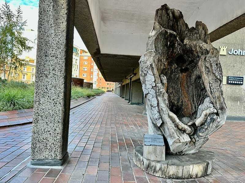
One final old-timer can be seen on the highwalk very close to the gold-refiner’s frieze. This is the last remains of the Mendelssohn tree, brought over from Burnham Beeches in Buckinghamshire when the tree collapsed in 1990 after 500 years’ growth. Felix Mendelssohn was a regular visitor to the woods, and supposedly sat under this beech when composing parts of A Midsummer Night’s Dream. It is just possible that his famous Wedding March was dreamed up on these very timbers. Why here? Well, the City of London Corporation manages Burnham Beeches. It also owns the nearby Barbican Arts Centre and the Guildhall School of Music, which occasionally put on Mendelssohn recitals. So I guess there are dots to be joined.
Aside from these fragments, I’m not aware of any other pre-1960s relics within the Barbican Complex. That said, I don’t have access to the keyholder-only areas, which may contain further secrets. I’d love to hear in the comments if you have any special insights.
Meanwhile, if you’d like to learn more about the buildings that occupied the Barbican area before the Blitz, A London Inheritance blog has an excellent in-depth account. And another.


_-_geograph.org.uk_-_3618551.jpg)