Adapted from a feature that first appeared in October 2025 on Londonist: Time Machine, our much-praised history newsletter. To be the first to read new history features like this, sign up for free here.
Today, we’re back in 1851, the year of the Crystal Palace and the Great Exhibition. And we’re poised hundreds of metres above the ground, looking south over the sprawl of London.
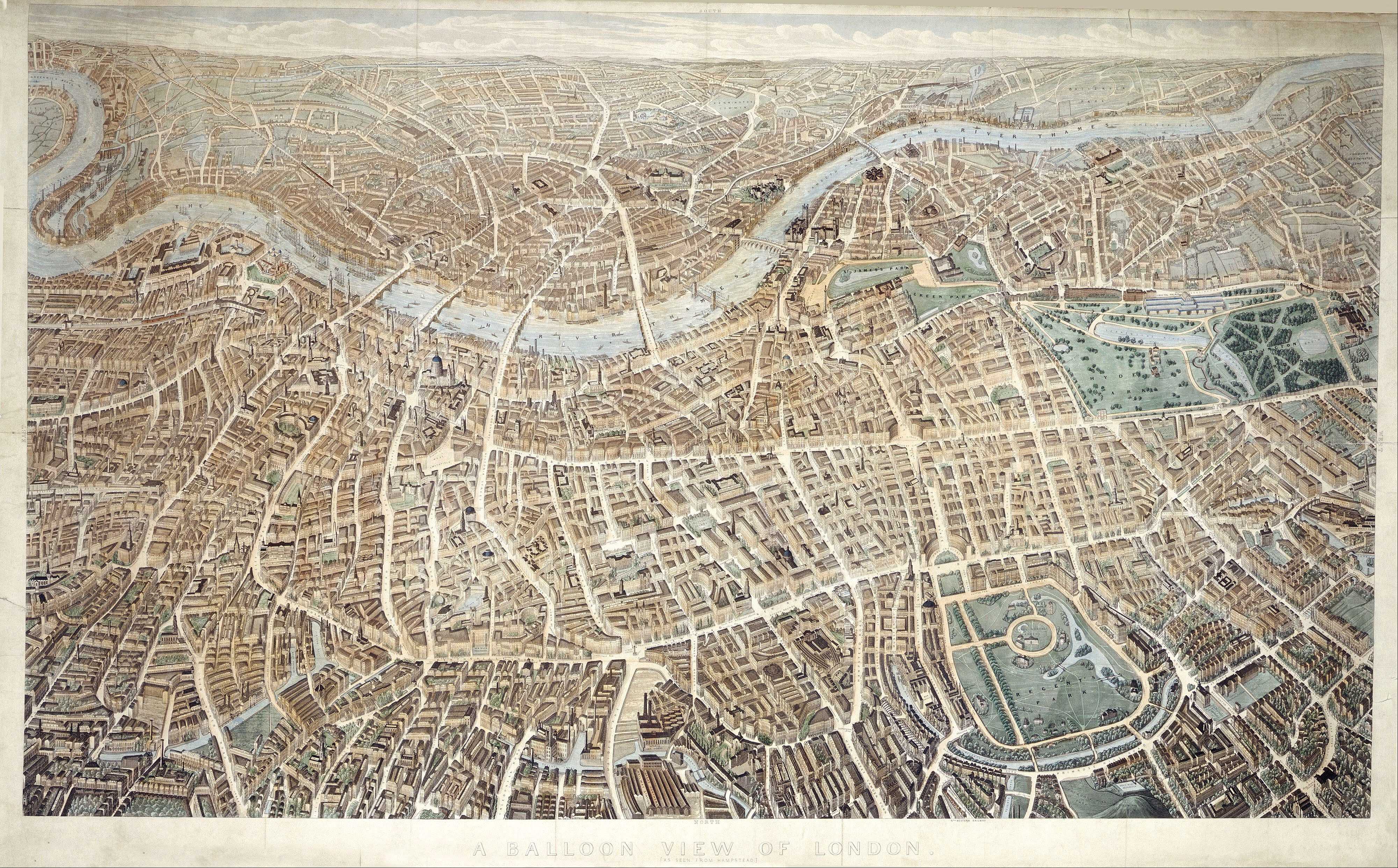
Have you got your bearings? We’re to the north of London, and specifically in the skies over Hampstead. Our view looks south. The park towards the bottom-right is Regent’s Park, while to the top-left we see the Thames curling around Rotherhithe and the Isle of Dogs.
Most of us have seen such views from an aeroplane window. But in the mid-19th century, such perspectives were novel, even astonishing. Perhaps only a few hundred people had ascended by balloon over London at this point. What did those privileged eyeballs take in? With photography still a temperamental novelty, artistic panoramas were the only way to communicate the view.
Despite its title — “A balloon view of London (as seen from Hampstead)” — this panorama was not drawn from a basket. It can’t have been. The cold, the wind, the motion, the peril and the expense of balloon flight would all conspire against the draughtsman. It’s possible that the anonymous artist made a preliminary sketch from a tethered balloon, but most of the work would have been done on the ground by cross-referencing with existing maps and drawings. It is a simulated ‘balloon view’ in the same way we might speak metaphorically of ‘a bird’s-eye view’.
The result is imperfect. For all its thrilling detail, the ‘balloon view’ is riddled with awkward perspectives and clunky proportions (just zoom in on St Paul’s). But we can forgive the artist. He or she was drawing more from the imagination than direct study. Their finished work is still a marvel to behold, and packed with insightful detail. It was published by Banks & Co. and sold from the Royal Exchange for six shillings, by Effingham Wilson from May 1851. Its publication was no doubt timed to entice wealthy out-of-towners, here for the Great Exhibition.
In many ways, the view shows familiar terrain. Parks and bridges and much of the road network are as we’d expect them today. Yet in other respects this is a very different city. Tall ships beshoal the Thames; much of the ‘Surrey side’, particularly to the south-east, is open fields; the early railway termini have begun to appear, but they don’t yet dominate their neighbourhoods. You’ll find no Shaftesbury Avenue, Charing Cross Road, Kingsway, Queen Victoria Street or Embankment. Of skyscrapers there are none; of stacks and steeples there are many.
Let’s zoom in on a few of the more intriguing areas. (Note: a slightly higher-resolution scan can be found under copyright on the London Picture Archive.)
The Crystal Palace
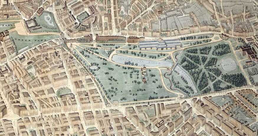
Hyde Park and Kensington Gardens are easy to spot. They closely resemble their modern forms, with the Serpentine/Long Water and Round Pond exactly as you’d expect to find them. But glance to the south (top) of the park and you’ll spy something that isn’t there today, and wasn’t there a year before. It’s the mighty Crystal Palace, built by Joseph Paxton to house the 1851 Great Exhibition. Without that unprecedented tourist magnet, our alleged balloonist’s view might not have been commissioned. The Crystal Palace would remain in this location for a year only. It was then dismantled and re-erected (with modifications) up in Sydenham, where it eventually gave its name to the area.
Look behind the Palace, and you’ll see a series of empty grey plots. These wouldn’t remain undeveloped for long. The profits from the Great Exhibition were ploughed into the area, bringing us the great cultural and academic institutions for which South Kensington is still renowned today.
The nascent King’s Cross station
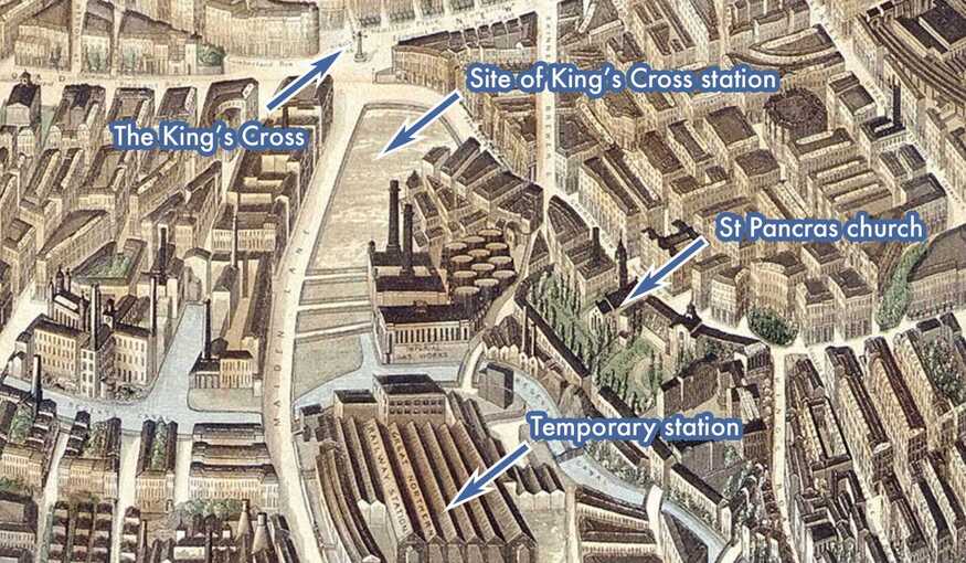
The other big development of the time was at King’s Cross. The Great Northern Railway had arrived in London just a year before, but its first terminus was not where you’d catch a train from today. A temporary terminus had been hastily built in 1850 to the north of Regent’s Canal, where now we find the Granary Building and St Martin’s College. It would be very short-lived. Look to the south (‘up’ in the image) and you can see the cleared plot where King’s Cross station was about to emerge. Construction would be complete by 1852, and would include a clock displayed at the Great Exhibition.
This small section of the panorama contains much else of interest. The feature I’ve marked as ‘The King’s Cross’ was a clock tower surmounted by a statue of King George IV. This glorified traffic island gave the area its name of ‘King’s Cross’, where before it had been known as Battle Bridge. Curiously, the monument and statue to the unpopular king had been demolished by 1845, six years before our panorama. It has no business being here. I suspect the artist has copied from older maps or illustrations without realising the monument had gone. Curiouser still, it is one of the few structures on the drawing to cast a shadow, and it does so in an impossible SSW direction (I do love nitpicking people who’ve been dead for over a century.)
We can also see the Imperial Gas Works, whose echoes remain in the modern Gasholder Park and apartments. Meanwhile, the ancient St Pancras church remains, though the cemetery buildings beside it have gone.
The West End
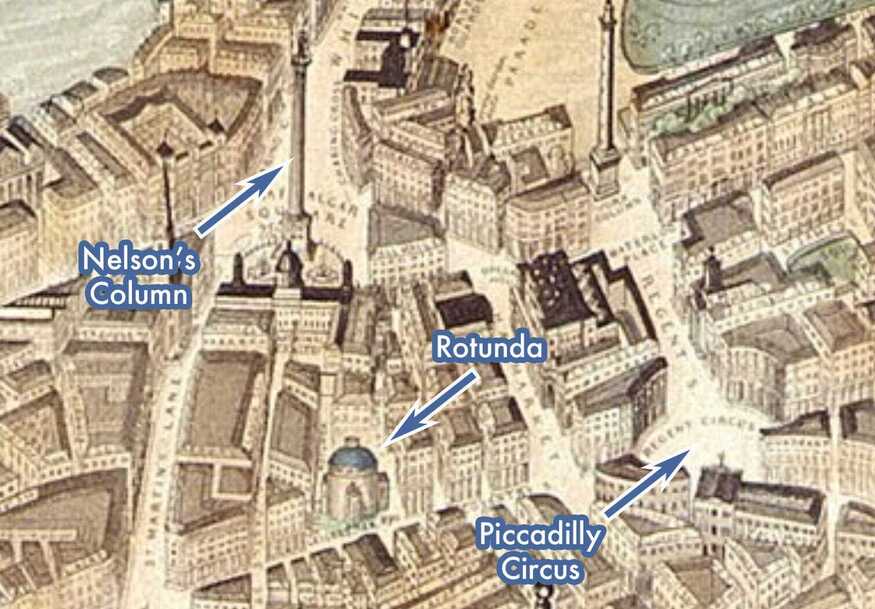
By 1851, the essentials of the West End were largely complete. Regent Street had been knocked through a generation before, Nelson’s Column and the National Gallery had been up for about a decade. It mostly looks familiar.
The eye is drawn, however, to a building that many of us will not recognise. This is the ‘Rotunda’, an early form of ‘immersive experience’ built just north of Leicester Square in the early 19th century. Its main purpose was to show off the huge panoramas of Robert Burford. These 360 degree paintings, much larger than our ‘balloon view’, would line its drum-shaped walls, transporting visitors to faraway places. Here’s a cutaway:
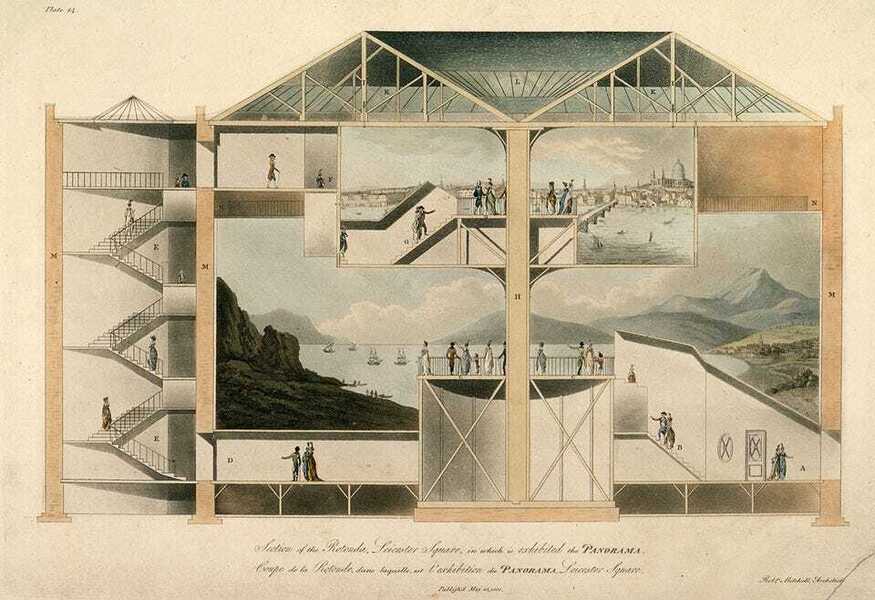
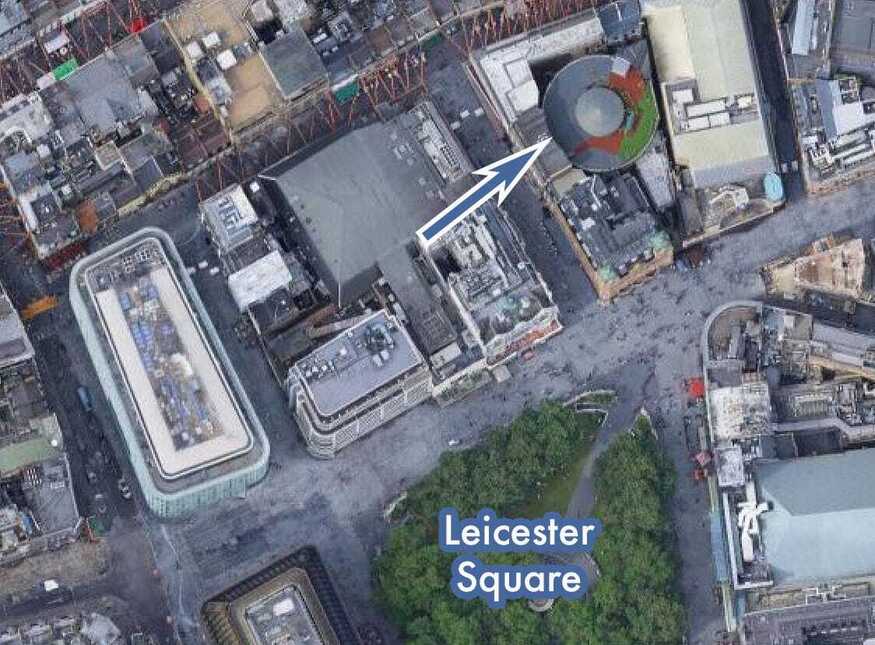
The rotunda was hugely popular — one of London’s ‘top tourist attractions’, as we might say today. What few people realise is that it still exists, and can be visited any day of the week. It now forms the shell of the Roman Catholic Church of Notre Dame de France, just north of Leicester Square. Its drum-shaped form cannot be recognised from the street, but it stands out in satellite view (along with its intriguing roof garden, which I’d love to see up close).
The South Bank
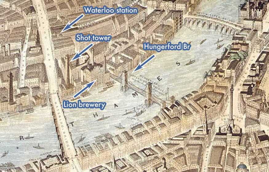
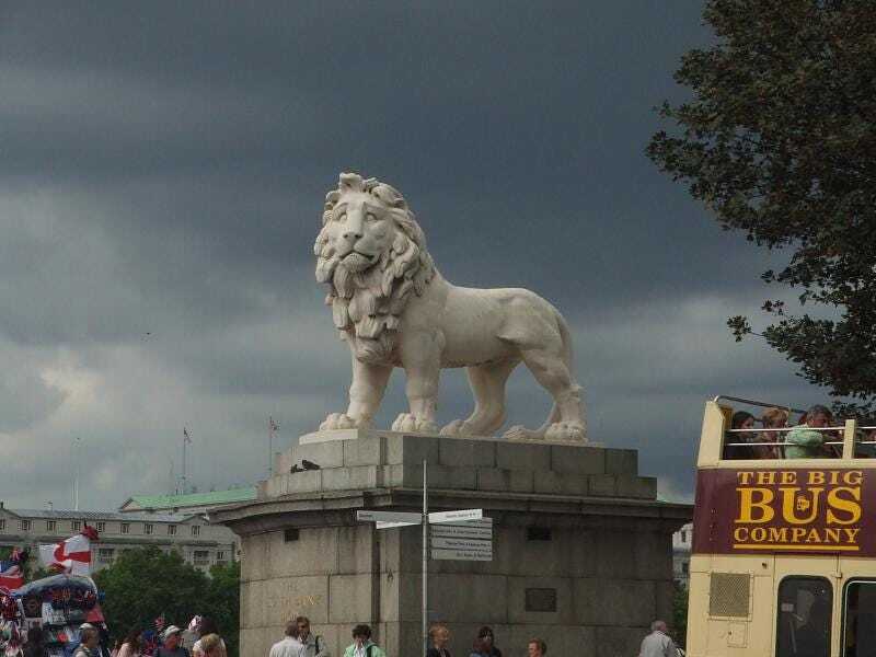
Like much of the river front, the South Bank was heavily industrialised in the mid-19th century. Indeed, it would remain so until half-way through the next century. The Lion Brewery (labelled) was only demolished in 1949 to make way for the Royal Festival Hall. Its rooftop lion still guards the area, from its plinth on Westminster Bridge.
The stack labelled as “Shot Tower’ would last even longer. It towered over the 1951 Festival of Britain, and was finally taken down in 1962. The Queen Elizabeth Hall now stands on the site. Meanwhile, Waterloo Station is already a presence, having opened about a decade before. It would grow much more prominent over the coming years and eventually give its name to the wider area.
Our panorama features eight bridges over the Thames; all have since been replaced. The one partial exception is Hungerford Bridge, depicted in 1851 as a pedestrian suspension bridge, and designed by IK Brunel. The deck and towers are long gone, but the supporting piers still hold up the Charing Cross railway bridge. (The suspension cables also had an afterlife, and were reused on Clifton Suspension Bridge in Bristol.) Meanwhile, the panorama is notably absent London’s most famous span. Tower Bridge would not be built for another 40 years. The Thames here is instead thick with tall-masted cargo ships, unloading at places like Hay’s Wharf and Butler’s Wharf.
Canals and railways
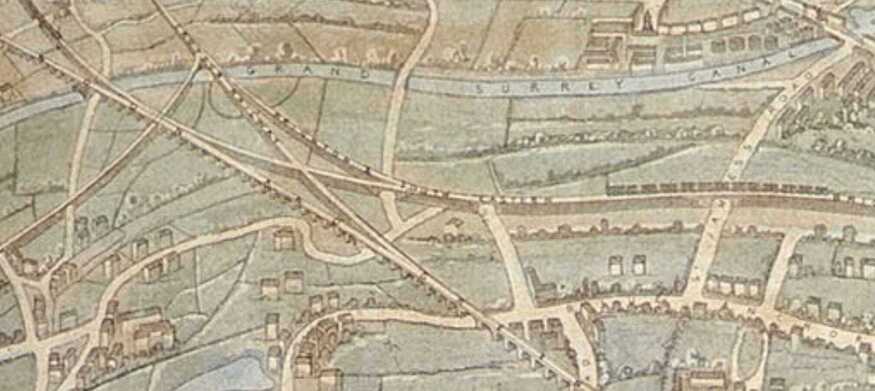
As already noted, the anonymous artist behind the panorama was not a draughtsman of the first order. The plan’s shortcomings are most keenly seen at the extremes. The fields and hedgerows to the upper-left, for example, are drawn with questionable perspective. Most egregious of all is the ‘Grand Surrey Canal’. This almost forgotten waterway was no wider than a typical canal, yet here it’s given the prominence of a major river (and perhaps even a lake as it curves towards Peckham).
The waterway was built in the early 19th century to take cargo inland from the Surrey Commercial Docks (upper-left of image). It remained intact until the Second World War, after which it was gradually filled in. Its route can still be followed easily, and features many leftovers of the canal, such as mooring posts and a bridge to nowhere in Burgess Park. I’ll write a feature on it one day.
More prominent still in this part of the image are the snaking rail viaducts heading off to the south-east (you can even see the trains). These remarkable structures were built in the 1830s to support lines into London Bridge, and they still carry trains today, almost 200 years later. The London to Greenwich stretch alone features 878 brick arches, a colossal undertaking in a time before power tools and machinery.