Maps (Lots Of Maps) At The British Library

Looks like this article is a bit old. Be aware that information may have changed since it was published.
Last Updated 07 November 2016
Maps have lots of uses. Some are simply used to get us from A to B. Others are used to plan the invasion of a country.
The British Library's Maps and the 20th Century: Drawing the Line is chock full of maps with interesting tales to tell, from a Soviet probe mapping the dark side of the moon to an EH Shepard map of Hundred Acre Wood.

The exhibition opens with a clever live heat map, showing the distribution of people within the gallery floor plan — a good way to see where the busy sections of the show are. Another nice touch are the maps drawn along the exhibition floor and up the display cases, immersing us in the world of cartography.
Maps at the exhibition vary wildly — one shows the tourist sights of Yorkshire, another plots out Disneyland — and there's a cartographic version of Sim City too.
But it's the section dedicated to war and peace, where some of the most fascinating stories can be found.

An Argentinian map of the Falkland Islands has all the place names in English with their alternative names in Spanish; Turkey's map of Cyprus only shows the northern Turkish half in any detail; a German map shows the distribution of German immigrants in the US in 1940 — this would have been used by Goebbels' propaganda unit to target advertising advising the US to stay out of the war.
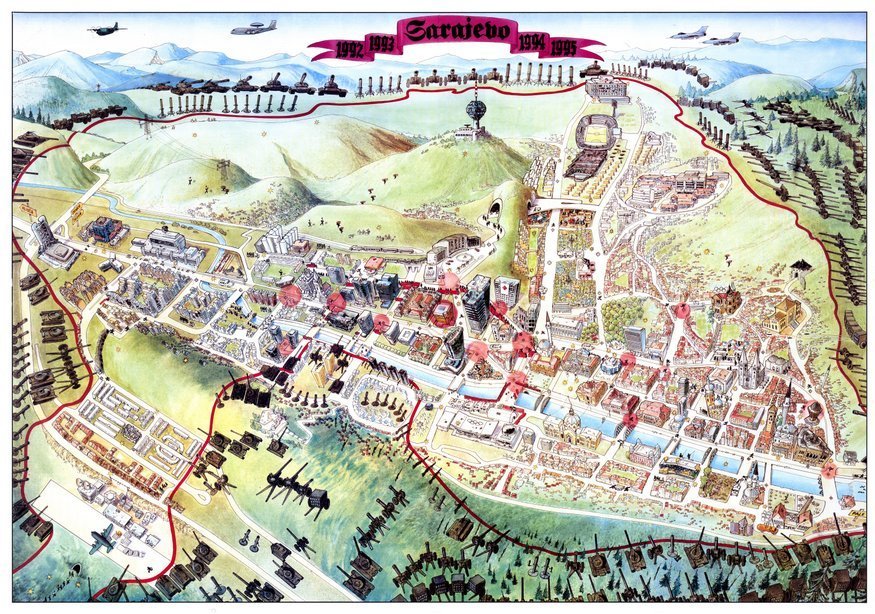
Some of the more disturbing maps include one recovered after the fall of the Soviet Union, showing how the Russians had mapped out Brighton to a remarkable level of detail, and a military training map showing a nuclear explosion having been detonated just south of Edinburgh.

War get a satirical spin too; cartoons depict both Hitler and the British Empire as spiders — their legs reaching across the world, while the Japanese empire is depicted as a malevolent octopus, its tentacles wrapping their way around the Pacific.
War themes and propaganda even spread to games. A rudimentary board game is built around Italy's invasion of Abyssinia while an old Harrods game requires negotiating a ball bearing through pockmarked trenches.
By grouping the exhibition into themes, the show does bounce around in terms of history and context. For example the original sketch by Harry Beck of the Underground map is at the opposite end of the exhibition from the Manhattan underground map. There are quite a few of these incongruous shifts.

However, one juxtaposition works quite brilliantly: a book designed to help children read maps is placed next to a GPS receiver. It's the very technology that means most born today will probably go through life without ever having to learn how to read a map.
Cartophiles will love this show, but anyone looking for a riveting exhibition should Google Map 'British Library' and make their way here.
Maps and the 20th Century: Drawing the Line is at The British Library until 1 March 2017. Tickets are £12 for adults, concessions available.