
No, is the quick answer. But the history of the Square Mile — more properly called the City of London — is worth a deeper ponder.
Half a square mile
Where did it all begin? London Version 1.0, or Londinium as it was known, was founded by a bunch of Italian immigrants, generally referred to as the Romans, around 43 AD. Their city was quickly destroyed by local tribes led by Queen Boudica. Its full extent can only be guessed at, but it certainly covered much of the space we today call the Square Mile.
A new city soon sprung up in its place. It was enclosed by a sturdy wall, whose remnants can still be traced today. The area within that wall covered approximately half a square mile. It probably looked a bit like the image below, which shows a 1920s model in the crypt of All Hallows by the Tower.

The old Roman city was abandoned for a time after the Roman retreat around 400AD. No one quite knows why — perhaps for superstitious reasons. It was resettled by Alfred the Great in the 880s. Very little is known about this restoration period. Eventually, though, the City once again took on the size and shape of Roman London, with renewed walls built up on the old foundations.
Doubling in size
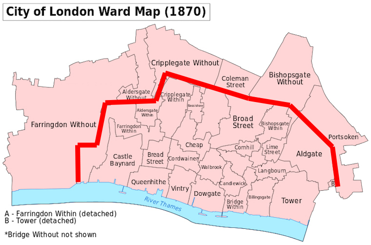
At some point in the long, medieval period, the areas immediately outside the Roman walls became sufficiently inhabited to be counted as city 'wards'. These outlying districts took on the label 'without' — for example, Farringdon Without and Bishopsgate Without — to indicate their beyond-the-wall location.
With the addition of the extramural wards, London effectively doubled in size to around 1.05 square miles — a situation that persisted for many centuries with only minor changes. The nickname 'The Square Mile' appears to be a Victorian invention — the earliest reference we can find is from the 1860s.
A further embiggening
At 1.05 square miles, the City of London pretty much lived up to its nickname. But the spoilsports at Guildhall changed a millennium of continuation in 1994 with some major changes. The wibbly wobbly boundaries you see in the map above were rationalised, while the border was also pushed out to the north-east to incorporate the new Broadgate complex. The effect was to increase the City from 1.05 square miles to 1.12 square miles. Here's another map to show what changed — old boundary in red, new boundary in dark blue (and the Temple area, which has a special status, shaded in pale blue):

Another consequence — which we hear caused some argument on the boundary committee — can be seen at the 12 o'clock position on the map. Goswell Road was partly brought under the jurisdiction of the City of London, where formerly it had bowed to Islington. For the first time in its history, the Square Mile contained a 'Road'. That story is told here.
So there we have it. The Square Mile is not a square mile, but 1.12 square miles — although it used to be half a square mile, and then 1.05 square miles. With tall buildings and new office blocks pushing ever deeper into Tower Hamlets and Hackney, perhaps the Square Mile will one day plumb yet greater depths of inaccuracy.


