What did the Romans do for us? Plenty. They founded the first version of London around 43CE, and laid out some of the roads we still use today. One thing they never got round to building, however, was an underground metro system. If they had, it might have looked something like this:
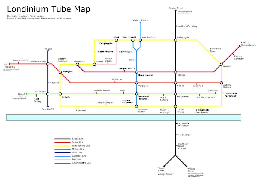
The map focuses on the walled centre of Londinium and some of the settled land across the water in Southwark. (The Thames would have been much wider at this time, and much of the South Bank and Bankside would have been marshland but, in traditional tube map style, we show only a schematic Thames.)
Stations indicate sites of major Roman landmarks, such as gates in the wall, municipal buildings and temples. Nobody knows what the Romans called their creations, so we've used the modern names, like Ludgate and Bishopsgate, which are medieval in origin. Stations in bold indicate locations where Roman remains are still accessible to the public; we've prepared a guide to these places here.
We've also included a few semi-mythical locations. White Hill is thought by some antiquarians to be the former name of Tower Hill, before that fortress was built by the Norman conquerors. There is no primary evidence for this, but the hill may have had some importance to the Romans, so close to the defensive wall. The Brill is a supposed Roman camp close to King's Cross.
The map was built with much reference to the Museum of London's wonderful map of Londinium, available in print or as part of the Streetmuseum app.
This article was originally produced as part of a media partnership with Museum of London.