

After the Soviet Union crumbled in the early 1990s, something altogether eerie was discovered.
Hundreds and thousands of maps of countries and cities throughout the world had been drawn up by Soviet cartographers, and annotated with Cyrillic script. Streets, buildings, industries, transport and utilities were pinpointed, often in exacting detail. This was some achievement in its own right, and altogether more astonishing given these were pre-Google days. Not to mention that the countries which featured in these maps were often doing their damnedest to hide such information from the Soviets.
In his book The Red Atlas: How the Soviet Union Secretly Mapped the World, John Davies pores over the maps, including those that were created of London. Here, we look at five extracts from a 'Soviet London' map printed in 1985. Altogether, it comprised four sheets at 1:25,000 scale, covering the area within the M25.
Central London
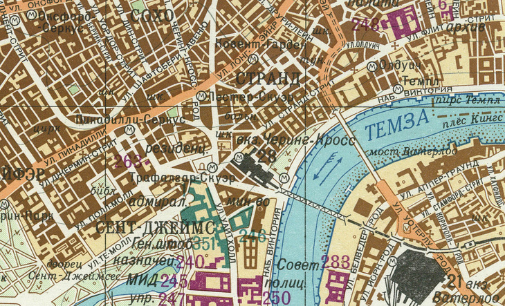
A map of central London shows several of the 'Important Objects' colour-coded, as Green (military), Purple (administrative) and Black (industry and transport). Among those flagged are the Ministry of Defence, 'State Archives' (this was Public Records Office), Treasury, Ministry of Foreign Affairs, Courts of Justice, Scotland Yard and Waterloo station and Charing Cross stations.
The cartographers didn't always get their labels right. Number 263, for instance, is 'Residence of the Queen and Prime Minister'. This is a rather amusing misunderstanding — it's actually Her Majesty's Theatre (not quite sure what the PM has got to do with it though).
The Thames is named in upper case letters, indicating 'navigable river', with short ticks along both banks flagging vertical banks, suitable for mooring (another concerning detail perhaps). The arrows in the river show the direction of flow, and that the river is tidal in the opposite direction.
Tube stations are shown with the letter M, for 'Metro' (the cheek of those Russians — it's the Tube, thank you). The Kingsway Tunnel is marked too, at the northern end of Waterloo Bridge.
Thamesmead

Yes, the Soviets mapped Thamesmead. And in this map, we get more mistakes.
A cable tunnel is marked running beneath the Thames to Barking. This is not shown on OS maps, but does appear on UKHO Admiralty Charts. However, the bathymetric data (the river depths and channels) shown on the Soviet map do not correspond to the Admiralty Chart.
Meanwhile, object 322 is listed as 'TV Station Woolwich' and 341 'Woolwich Atomic Centre'. Neither of these items appear on any local maps of the time. The site was previously a weapons-testing range, but this was discontinued and the land was sold for housing in the 1960s. It's fair to say some guesswork was at play here. Still, the detail is such that individual residences are marked out in brown.
Mayfair

The US Embassy in Grosvenor Square is marked as object 350, and listed in the index as 'HQ US Navy in Europe' — close enough.
The map of London, by the way, was accompanied by a booklet with a descriptive essay of about 2,000 words describing London and its environs under headings such as General Information, Industry and Transport, Economy, Topography, Climate and Communications.
Stanmore

Bentley Priory is labelled 352 and listed as 'HQ Allied Powers NATO', an identity not shown on OS or other maps. In fact, this was the wartime HQ of RAF Fighter Command — as covered in our article about it.
London 'Metro' map

Here's a section of the London Tube map, which contains a number of errors, including transposed stations, misspelled names and non-existent sections of line and interchanges — possibly arising from trying to draw a geographic diagram of a complex network from a simplified London Transport Tube map.
Some of the errors include Brixton misnamed East Brixton (Ист-Брикстон), Pimlico misnamed Timlico (Тимлико) and its location transposed with Vauxhall (Воксолл) (Vauxhall is south of the River Thames).
Incidentally, the Russian word for 'railway station' (вокзал) pronounced 'vok`za'’ is derived from this former terminus station and pleasure gardens. Oh yes, and as we've covered before: London does not have a 'Metro', OK.
The Red Atlas: How the Soviet Union Secretly Mapped the World, by John Davies and Alexander J. Kent, published by University of Chicago Press.
We featured this book because we know it's the kind of thing our readers will enjoy. By buying it via links in this article, Londonist may earn a commission from Bookshop.org — which also helps support independent bookshops.


