Adapted from a feature that first appeared in September 2025 on Londonist: Time Machine, our much-praised history newsletter. To be the first to read new history features like this, sign up for free here.
Behold, Elizabethan London, as though drawn by Tolkien.
This almost-huggable cartography is not hand-drawn, in fact. It’s woven. And by hands that withered away 400 years ago. We’re looking at one of the Sheldon Tapestries, commissioned by wealthy landowner Ralph Sheldon in the 1580s.
Sheldon lived in Long Compton in Warwickshire. He was among the earliest to reach the correct conclusion that maps are the best things ever. He also had close links to Richard Hyckes, one of the most high-profile tapestry makers of the time. And so Sheldon commissioned four tapestries to show the surrounding counties, based on earlier paper maps by Christopher Saxton (a wonderful rabbit-hole in their own right). The four counties were Gloucestershire, Worcestershire, Oxfordshire and Warwickshire, offering a wraparound representation of England’s left hip, and a tough pronunciation test for any American readers.
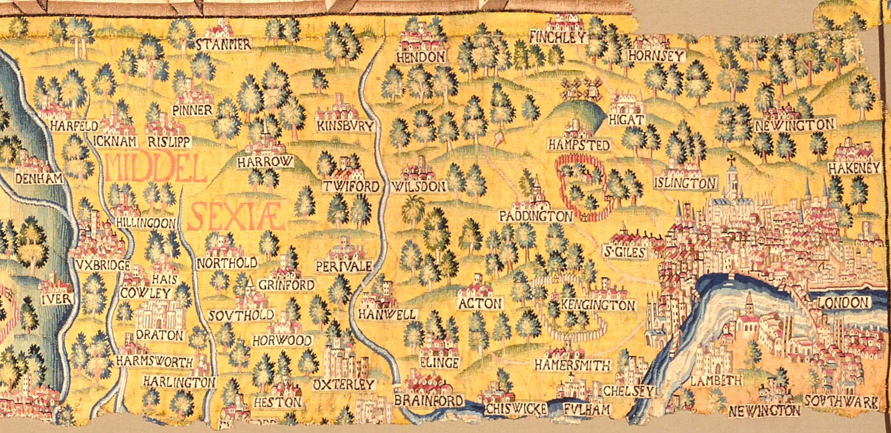
London, of course has never been part of any of those counties. Happily, the anonymous loom-whisperers who crafted the Oxfordshire tapestry shuttled far enough east to include the capital, as well as large chunks of Middlesex. Let’s get stuck into it.
We’ll first zoom on central London or, as it would have been considered then, ‘the whole of London’.
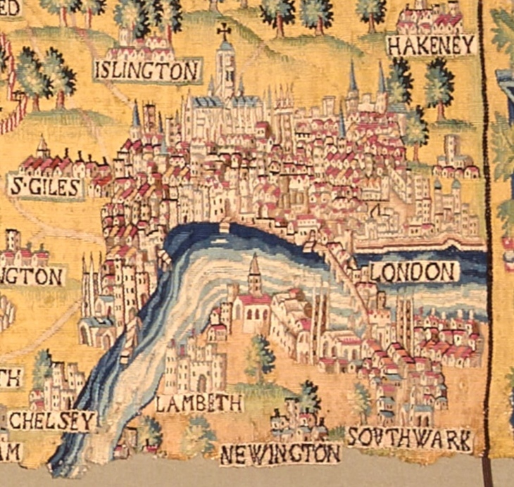
The view gives us some of the earliest representations of famous London landmarks. The most obvious, rising out of the main cluster, is Old St Paul’s Cathedral. It’s farther north than it should be, as though centuries of proximity to the Thames have carried the cathedral chromatographically up the fabric.
This mighty building was easily the tallest structure in the city. Though it would lose its spire in 1561, and burn down in 1666, nothing would surpass its original height until the Post Office Tower (now BT Tower) in 1964.
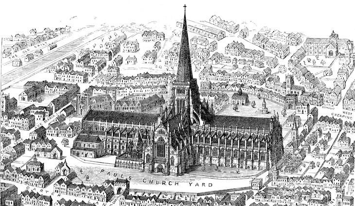
Its depiction in the tapestry shows the cathedral without its spire, as would be expected two decades after its loss. The remaining tower is somewhat elongated from reality — a common occurrence on the tapestry.
Nearby, London Bridge is prominently depicted, crossing over to Southwark. It is encrusted with buildings, as would be the case for another two centuries. One day, when we’ve moved on from buses and motor cars, the houses will be back again.
Other discernible landmarks include the White Tower at the centre of the Tower of London, a rather squashed Westminster Abbey and Palace of Westminster (and possibly Whitehall), and Lambeth Palace across the water. Also on the southern bank, St Mary Overy (now Southwark Cathedral) and St Olave’s (now demolished) are clear either side of London Bridge.
The prominent steepled church on the tip of the south bank is, I think, a fiction. The land around here was marshy at the time, and no church would be built until Christ Church a century later. Sadly, we’re just a bit too early to see Shakespeare’s Globe, which was erected on Bankside about a decade later. At the time of the tapestry, it was still located up in Shoreditch, though it can’t be seen on the map.
Let’s zoom out a little now, and take a look at north London:
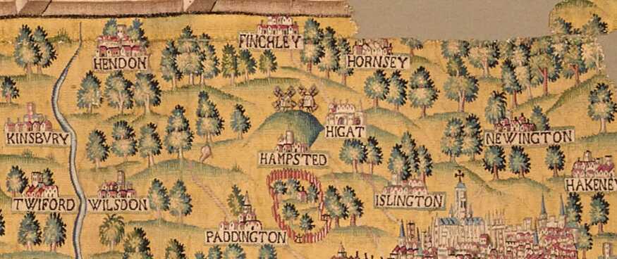
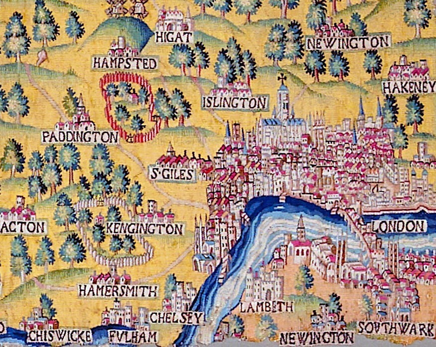
The northern heights look so neat and ordered, don’t they? The area shown above is now almost total sprawl, with only parks, playing fields and Hampstead Heath to break things up. Spelling was not standardised at this point, and hence we find Wilsdon (Willesden), Hakeney (Hackney) and Higat (Highgate). Funnily enough, the automated announcements on the Northern line still pronounce that latter place as ‘higat’, something I’ve never noticed elsewhere in real life.
Most of the place names here should be self evident. ‘Twiford’ might be an exception. It still exists as (West) Twyford, a small area north of Park Royal that rarely calls attention to itself. Newington is Newington Green, just south of Stoke Newington, and not to be confused with Newington in Lambeth (which is also shown).
My favourite detail here is the fenced area just east of Paddington. You’re looking at what will one day become Regent’s Park. In Elizabethan times, this was a royal hunting ground known as Marylebone Park, which was evidently enclosed with a wooden fence, or ‘pale’. The phrase ‘beyond the pale’ harks back to this usage, though probably not this specific example.
A few faint roads are woven into the map. The one leading from Paddington up towards Hendon is the Edgware Road, part of the Roman Watling Street, which was already more than a thousand years old when these threads were intertwined. Meanwhile, the Islington-Highgate-Finchley Road is part of the Great North Road.
The river snaking north-south on the left-hand edge of the map is the Brent. This is one of a tiny number of London place-names that predate the Anglo-Saxons and, indeed, the Romans. It’s thought to be of Celtic origin, perhaps linked to the goddess Brigantia.
Now let’s turn our gaze to west London.
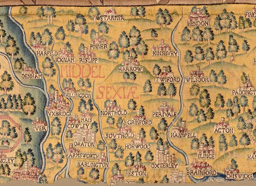
Well, I say ‘west London’, but the tapestry calls it MIDDEL SEXIÆ… which literally sounds sexier. Here we see a gladdening of villages, slotted in among a quartet of rivers. Left to right, these are the Colne, the Yeading Brook, the Crane and the Brent again. The Brent reaches the Thames at ‘Brainford’, which we would call Brentford.
Most everything east of the Colne (left-most river) is today part of Greater London, although many denizens of places like Uxbridge and Pinner still cleave to the Middlesex identity, 60 years after that county was abolished for all practical purposes.
Things to note… Look at Harrow standing all lofty there on its hill. That hasn’t changed, although the name has since spread to cover the lowlands around the hill and, indeed, a whole London Borough. Uxbridge sports what looks like a skyscraper — presumably a church tower, not that it’s ever had one so dominant. The enclosure, or pale, to the bottom-left is the old hunting grounds of Langley Park.
You’ll spot some confounding spellings in there: ‘Hais’ is, of course, Hayes. The campaign to revert to that earlier spelling starts here, so we can finally distinguish it from Hayes in Bromley. Southold and Northold have evolved into Southall and Northolt. Oxterley is, of course, Osterley; Stanmer, Stanmore; Grinford, Greenford.
A few names may be unfamiliar, even to Londoners. Cowley, south of Uxbridge, still exists, but rarely gets any press. It’s best known for Brunel University. The most intriguing here is ‘Horwood’. No place of that name is recorded on any other source I can find for that time. I suspect this is the village of Norwood Green, and the map’s original compiler mis-heard or mis-transcribed some information.
Finally, this is one of the most visited parts of London. You’ve very probably been yourself:
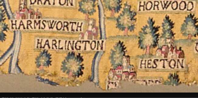
I wonder what the tapestry weaver was thinking about when she/he was immortalising these villages in wool and silk. Did they wonder what life was like in Harmsworth, Harlington, Horwood and Heston? Were they aware of another ‘H’ village round there called Heathrow? We’ll never know. They certainly never imagined what the loom of time would weave for this village, centuries hence.
Viewing the Sheldon tapestry
Sadly, the original Oxfordshire (plus London) map is in tatters, though we’re lucky that the London section survived. The fragmented remains can be seen at the Weston Library in Oxford, while the Ashmolean Museum holds a 17th century copy that is more complete. These things are huge: around 5.5 metres wide by 3.5 metres tall. What a sight it must have been, hanging with its three stablemates in the home of Ralph Sheldon in the 1590s. I now know what I’ll spend my millions on when I finally win the lottery.