This is a sponsored article on behalf of the Museum of London Docklands.
Ever considered a fishing trip to Mayfair? The Tyburn Angling Society has. This organisation formed in the 1990s with one goal: to bring back the lost River Tyburn, which once flowed through the neighbourhood on its way from Hampstead to the Thames.
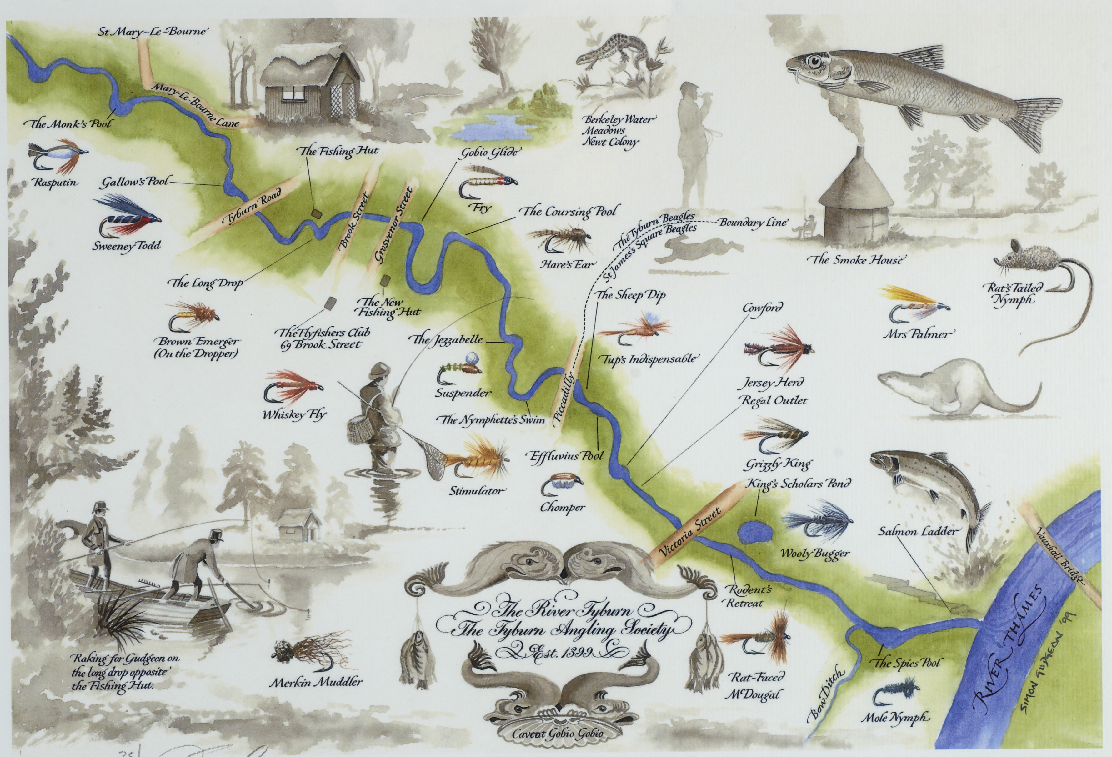
The society produced this charming map of the lost waterway, which piqued our interest at the Museum of London Dockland's Secret Rivers exhibition. It shows the route of the Tyburn, and suggests the prime fishing spots, should it ever be restored.
It could happen... in theory. The river still exists as a sewer. Bringing it back would be hugely expensive, not least because any re-emergence would require compulsory purchase and demolition of some of London's most exclusive properties. But what a dream, eh?
Although long-buried, it is still possible to find signs of the vanished watercourse if you know where to look. Here are a few places to wet your appetite, if not quite your toes.
1. The telltale twisty streets
Have you ever looked closely at a street plan of Marylebone and Mayfair?

Both areas are based on grids, but something curvy disrupts the regular criss-cross. Roads like Marylebone Lane and Bruton Lane are much more wiggly, because they follow the route of the Tyburn. Once you notice this for the first time, you'll wonder how you never spotted it before.

The Secret Rivers exhibition reproduces another map by the Tyburn Angling Society, showing how the river might look were it allowed to flow through Mayfair once again.
2. Look at the slope of the land
Rivers create valleys — that much we all learnt at school. A river may be deleted from the landscape, but its valley is harder to obscure. The Tyburn was never a large river. Its valley is subtle, but plainly visible in places like Wigmore Street, Oxford Street and Piccadilly.

The slope is perhaps most readily seen in Green Park, where a clear valley runs south of Brick Street (it's hard to do it justice in a photograph). An ornamental pool, fed by the Tyburn, existed here in the 18th century, but has long vanished.
Traces of the valley peter out as you head deeper into the park, but the river eventually wends its way beneath Buckingham Palace. The Tyburn Angling Society would see the palace demolished to resurrect the river. Her Majesty's views on the matter are not recorded.
3. Visit the source
But let's back up a little. Where does the Tyburn start? Like its sister rivers, the Fleet and the Westbourne, the Tyburn starts its flow on the slopes of Hampstead. It no doubt collects together from multiple springs and run-offs, but the traditional source is marked as Shepherds Well, on the corner of Fitzjohn's Avenue and Akenside Road.

The promised fountain no longer issues forth, but the site is handsomely marked by a red-brick memorial and tablet.
4. See where it meets the Thames
After flowing down through Swiss Cottage and St John's Wood, the river/sewer is carried through the Chalbert Street footbridge over the Regent's Canal (you can't see the pipe) and on through Regent's Park. It once fed the park's lake, but has long been diverted into the sewers.
After Marylebone, Mayfair and Green Park, the river wends its way south through to Victoria. Here, it splits into two branches. The first makes a beeline for Westminster. In days gone by, the waterway split again, providing several openings into the Thames. One of the high points between these delta-like rivulets was known as Thorney Island, upon which Westminster Abbey was constructed.
All traces of the Tyburn in this area are long obliterated, with one exception. Stand on Lambeth Bridge and look to the north bank. Here, at low tide, you will see the gate to a storm relief drain. Following heavy rain, when the sewers are full, the Tyburn still overspills into the Thames at this point. The under-construction Thames super-sewer should make this all-but-redundant.

Remember how the Tyburn bifurcates at Victoria? The southern branch heads down through Pimlico towards Vauxhall Bridge. Here, its confluence with the Thames is again easy to see at low tide. Look beneath these distinctive white buildings, a little south-west of the bridge, and you'll spot the cave-like mouth of the Tyburn sewer.

A visit to the site reveals this ornamental plaque, which reminds us of the long route down from Shepherds Well.

5. Touch its waters (possibly)
Back in Mayfair, there's one place you can actually touch the waters of the Tyburn, if its custodians are to be believed. Grays Antique Centre is a subterranean market for second-hand goods just behind Bond Street station. It has a most peculiar water feature — a narrow channel populated by goldfish, and spanned by what must be London's smallest bridge.

Grays claims that its curious bauble is part of the River Tyburn. The notion is fanciful. Remember, the Tyburn is now a sewer, which would not be a desirable feature in a shopping hall, not to mention the stress on the fish. It could conceivably be a feeder stream from some unknown water source, but it's hard not to be sceptical.
6. Look for telltale names
Other hints of a watery past can be found along the course of the river — we've already met Spring Path on the heights of Hampstead, for example. Marylebone itself takes part of its name from the Tyburn. It recalls the church of St Mary beside a 'bourne', which is an old name for a small river (i.e. the Tyburn). Elsewhere, you'll find Brook Street in Mayfair, whose most notable resident, Handel, was famous for his water music. Tachbrook Street in Pimlico appears to continue the theme, and is another curved road that follows the river's course, but its name is coincidental.

The Tyburn name was once used for a small hamlet near modern day Marble Arch. It was most infamously applied to the gallows here, known as the Tyburn Tree — London's main site of execution until 1783. Nearby Tyburn Way, Tyburn Convent and Tyburn Gallery perpetuate the name with more civility. The site of Tyburn Manor House is marked with a plaque some distance away, at the top of Marylebone High Street.

7. Visit the exhibition
After you've finished exploring the streets for clues, it's time to head to the Museum of London Docklands to find out more. The Secret Rivers exhibition contains hundreds of artefacts relating to the Tyburn and other London rivers, and displays numerous maps and artistic visions not readily available elsewhere.
Who knows, you might even be tempted to join the Tyburn Angling Society.
Secret Rivers exhibition runs at the Museum of London Docklands until 27 October 2019. The nearest station is West India Quay (DLR). Entrance is free. Read our review here.