In February 2017, a parcel arrived at Londonist Towers, inside which was a map of London in 1862, from Stanfords travel bookshop. The map went up on the wall, and no work was done for the rest of the day as team members took turns to pore over it. Here are a few of our favourite finds:
Charing Cross station...

...only just missed out being included in this map — it was built in 1864, two years after Stanfords' cartographers did their work. The Hungerford Suspension Bridge — which took its name from the market which sat where the station now is — already crossed the river at this point. Of course, the Golden Jubilee footbridges which now span either side of the railway bridge didn't open until Queen Elizabeth II's Golden Jubilee in 2002.
Interestingly, the black and white dotted line which can be seen in the right of the picture above is the railway line coming up from Waterloo, suggesting it had already been built this far in preparation for the station opening two years later.
Downing Street

The street existed, but the area just to the south of it was earmarked as 'Site For New Foreign Office' — and lo and behold, it's where the Foreign & Commonwealth Office sits today, right by the Cenotaph (the two Offices merged in 1968).
We'll be honest, we're not as familiar with this building as we are with other London structures. Nothing like the eternal presence of armed police in the general area to deter you from pressing your nose up against the window and having a gander.
The Lion Brewery

On Belvedere Road, where Southbank Centre sits today, the Lion Brewery could be seen in 1862. Here's what the brewery looked like in 1932. It was owned by a James Goding, and opened on the site in 1836, staying there under various names (and, later, various states of dereliction) until it was demolished to make way for Royal Festival Hall for the Festival of Britain in 1951.
The lion perched at the end of Westminster Bridge used to sit atop the brewery. Find out more about him — including why he's got a time capsule up his bum — here.
Harrods...

...wasn't around back then, and although Knightsbridge wasn't the countryside proper, it was a lot more rural than today's supercars would have you believe. Today, the department store sits to the south of Brompton Road, roughly where the extinct Queen Street is marked on this map. The central patch of greenery, Hans Place, still exists, as does Cadogan Place — although it's now a private garden with an NCP car park underneath.
What was the Princes Club (an exclusive gentlemen's tennis club) in 1862 is now one of the most expensive addresses in the UK — Cadogan Square — while the adjoining Market Garden has been transformed into an array of town houses and mews streets.
Trafalgar Square...

.... did exist, Nelson placed firmly atop his column and even getting a namecheck on the map. These were the days when the Square's upper terrace was still open to traffic, and the central tourist haven of pigeons and fountains was an island roundabout.
But more fascinating than that is what lies to the north of the Square. The National Gallery, which opened in 1838, can be seen, then with the Royal Academy as a bedfellow rather than today's National Portrait Gallery. Behind that, though, is St George's Barracks, which used to accommodate regiments of foot guards until demolition in 1911.
Westminster Cathedral
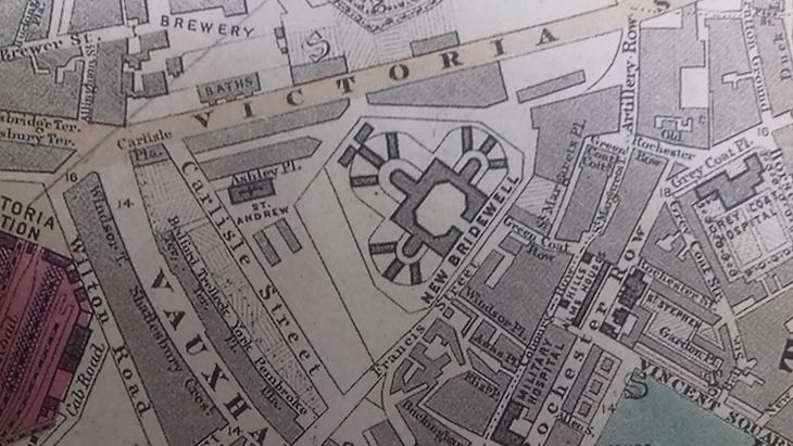
The Westminster area looked largely the same as it does today; Victoria Street sweeping down from Westminster Bridge to Vauxhall Bridge Road. The Houses of Parliament and Westminster Abbey were in situ... but Westminster Cathedral was not.
The cathedral building wasn't completed until 1903. 'New Bridewell' on the map refers to the Tothill Fields Bridewell Prison, a spin-off of the better-known Bridewell Palace. The site that the cathedral now sits on was home to a prison for over 250 years before taking on a more holy role.
Get your own copy of this map and see what differences you can spot. It's like Where's Wally for (geeky) grown ups.