
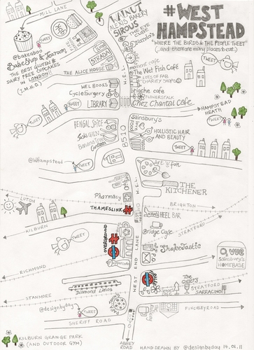
Rachel Day of West Hampstead sends us this exquisite map of her manor. As well as pointing out all the key restaurants, bars and shops, Rachel also highlights the homes of local Tweeters - let's hope there aren't any web-savvy housebreakers reading in NW6. As the map suggests, the area is replete with Twitter activity, centred around the excellent @WHampstead feed. Rachel herself can be found on @designbyday.
If you'd like to have a go at doodling your own neighbourhood, send images to tips - at - londonist.com. To be considered for our upcoming exhibition at the Museum of London, you'll need to get the hard copy to us by the end of next week (address supplied upon application).
Previously: Albertopolis, Angel to Bankside, Borough of Southwark, Brixton as a tree, Central London, District Line (Wimbledon Branch), Central London with no street names, Driver's Mind Map, Fleet Valley, Hackney, Hampstead Heath, Hoxton Square, London as a grid, King's Cross and Islington, Mayfair, Mayfair Squares, New Cross, New Cross (the fields of), Notting Hill, Paris versus London, Patchwork London, Pimlico, River Fleet, Rivers, Stoke Newington, Stratford, Toilets, Walthamstow by mother and daughter, Westminster kettling.


