
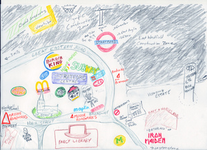
This week's doodled cartography comes courtesy of reader Ezekiel Melquist. He's chosen the Olympic gateway of Stratford for his subject. The depiction makes the area look like a bleak, corporate-chain hell. You might agree. We couldn't possibly comment.
The map, which is oddly oriented with North being somewhere off to the right, fixes the area within very narrow time boundaries. Very soon, the Olympic site will be complete, the various depicted roadworks will be gone, and the Starbucks logo will have changed. But the Cart & Horses will forever be the "Birthplace" of Iron Maiden.
Feeling inspired? Why not sketch up a map of your bit of London (or the wider city under an unusual theme)? The best maps will be selected for our upcoming exhibition at the Museum of London. Send entries to [email protected]. But soon - we'll be choosing the maps for exhibit in just two weeks.
Previously: Angel to Bankside, Borough of Southwark, Brixton as a tree, Central London, Hampstead Heath, Central London with no street names, Driver's Mind Map, Fleet Valley, Hoxton Square, London as a grid, King's Cross and Islington, Mayfair, Mayfair Squares, New Cross, Notting Hill, Paris versus London, Patchwork London, Pimlico, River Fleet, Rivers, Stoke Newington, Toilets, Walthamstow by mother and daughter, Westminster kettling.


